


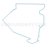
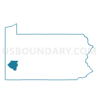
PITCAIRN DIST 03, Allegheny County, Pennsylvania
About
Outline

Summary
| Unique Area Identifier | 656270 |
| Name | PITCAIRN DIST 03 |
| County | Allegheny County |
| State | Pennsylvania |
| Area (square miles) | 0.15 |
| Land Area (square miles) | 0.15 |
| Water Area (square miles) | 0.00 |
| % of Land Area | 100.00 |
| % of Water Area | 0.00 |
| Latitude of the Internal Point | 40.40711810 |
| Longtitude of the Internal Point | -79.77367990 |
Maps

Graphs
Select a template below for downloading or customizing gragh for PITCAIRN DIST 03, Allegheny County, Pennsylvania


Neighbors
Neighoring Voting District (by Name) Neighboring Voting District on the Map
- MONROEVILLE WD 01 DIST 02, Allegheny County, PA
- MONROEVILLE WD 01 DIST 04, Allegheny County, PA
- PITCAIRN DIST 01, Allegheny County, PA
- PITCAIRN DIST 02, Allegheny County, PA
Top 10 Neighboring County Subdivision (by Population) Neighboring County Subdivision on the Map
- Monroeville municipality, Allegheny County, PA (28,386)
- Pitcairn borough, Allegheny County, PA (3,294)